Saturday, April 29, 2006

The Colca Canyon

Our normally trustworthy Lonely Planet quotes the Colca Canyon as being 3 191m deep. I have no idea what that means or how its measured and frankly I don´t care! Hills that big mean good walking and that´s just what we did.

For three days we walked in and around the Canyon (just to the left of my hand in this photo you can make out the village where we stayed the first night in a well set up dorm for gringo´s).


We had a nice sized group of 8 people with 2 guides to do a three day journey through the Canyon. One guide (Nestor) was super cool and informative and taught us about the medicinal and commercial benefits of many of the local plants. The other guide (Pablo) was a super tough local who was up and down the hills like a rabbit carrying all sorts of things. Not bad for a 50 year old. I walked out of the Canyon with him and its fair to say he is my first Latin American friend! We had a few strained yarns with my crappy Spannish but thanks to the powers of sign language we managed a few laughs.

We left Arequepa very early in the morning so we could walk down in daylight and the views were magnificent:


Perhaps our group was a bit slow or perhaps we didn´t get up early enough because come dark we were still 40 minutes from our accomodation. Also at that moment a thunderstorm started. Personally, walking in the dark in the Canyon in pouring rain with thunder echoing down the valley was an absolute highlight.

On day 2 we worked up enough of a sweat to enjoy a soak in the natural pools.


And the only way out was up the zig zag to home


And the best news of all was that I discovered Nestle Peru´s ¨Sublime¨ chocolate bar at the top. And boy it was Sublime - after demolishing two of them, I had no choice but to get 4 more!

Monday, April 24, 2006

Puno and the Uros Floating Islands - Peru

Our first stop in Peru was Puno where, aside from eating tremendous three course meals, the main attraction is visiting the floating islands on Lake Titicaca.

The science of the floating islands was fascinating - essentially the Uros people use the reeds and the roots of the reeds that grow in certain parts of Lake Titicaca to build themselves floating islands to live on. These days the science of the islands is overshadowed and the novelty of the floating islands is little more than a fiction used to lure the tourist dollar.


We made our token contribution and then carried on our boat ride a few more hours out on the lake to the very real and very big island of Amantani. We stayed the night with our host Bastilla and her family. Bastilla and her mother turned on some outstanding feasts for us in their pokey little kitchen lit by a single candle (and unfortunately my flash).

We ended the day than with a walk to the top of the island to watch the sun set over the endless crops of the locals.

And then we boogied with the locals.

Friday, April 21, 2006

Lake Titicaca & the Island of the Sun

We unpacked our walking shoes and with regret left our cushy lodgings at La Cupula and headed for the boat to take us to Isla Del Sol (Island of the Sun) on the Bolivian side of Lake Titicaca.

Our loaded boat made hard work of the journey and it took us over two hours to make the short trip of about 25 kms to the Island.

We unwravelled our legs, boofed a delicous egg burger and ripped into the 10km walk to Yumani, the main township on the Island. The start of the walk was gorgeous, with a small township full of wood and stone fences enclosing the precious vegetables of the locals.


We strolled uphill to our first stop and first taste of Inca ruins. It really is a tribute to how well these buildings are made that they are still standing some 500 plus years after their creation.


We made it to our destination without worry and our digs at Hostel Inti Wayra were marvellous for just 70 Bolivianos a night (NZD about $12). We had views of volcanoes exceeding 6000m and the Island of the Moon accross our balcony - stunning.


The next day we found a local chap who was kind enough to zip us accross the small straight to Yampuputa and we strolled back the 17km to our sanctuary at Copacobana.

The World's Most Dangerous Road

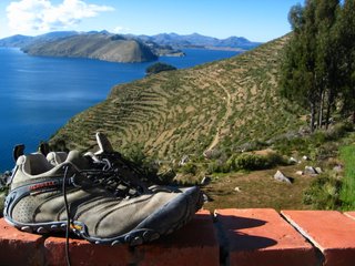
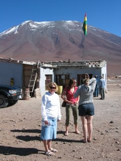
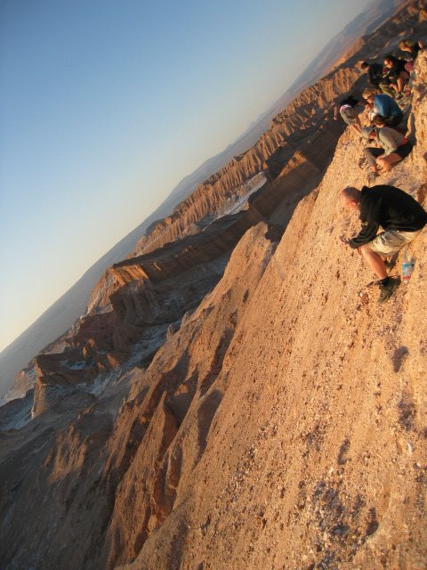
Hamish and I woke early and had breakfast at the designated meeting place. We were setting off to mountain bike down the "World's most dangerous road". Now, I thought that this designation was dreamt up by the marketing department of Gravity Assisted Mountain Biking- the first company to organise the descent on mountain bike, but I was wrong. The road was in fact named as the world's most dangerous road by the Inter American Development Bank in 1995. It was so named because in 1994 no fewer than 26 vehicles had fallen over the side, accidents which invariably resulted in the death of all occupants. The death toll in the last ten years has not abated with a fatal accident occurring on average every two weeks amounting to two hundred deaths per year.

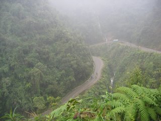
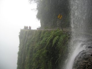
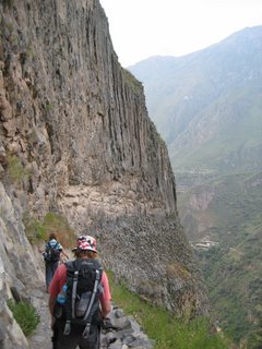
The road was built by prisoners in 1932 and connects La Paz to Coroico, the Yungas and low lands beyond. It is the main thoroughfare for those traveling from La Paz to Brazil- a journey which takes around a week. The fact that the drivers have driven for so long without a break and with only extract of the coca plant to keep them awake may account for some of the danger of the road. The rest of the danger comes from the road itself. It is a dirt track, barely passable in the wet season, at some points the road is only three meters wide and beyond that is at least a 500 meter drop- and never less than the distance required for a falling object to reach terminal velocity. There are of course no barriers to protect the users from the abyss. Some years ago, the Bolivian government decided that the road would be open to traffic in only one direction, on alternate days. It was acknowledge, however, that this system would not work when it transpired that a small bribe at the police check point circumvented the system - allowing cars to pass on the wrong day- making the road twice as dangerous as before. Instead, a new system was adopted whereby uphill traffic has the inside track on the left and the downhill traffic is on the outside. We were told that this is because the uphill, often heavily laden traffic, always has priority and does not stop but it is also so that the drivers of the downhill traffic- with the drivers seat on the right- can see just how close to the afterlife they are.


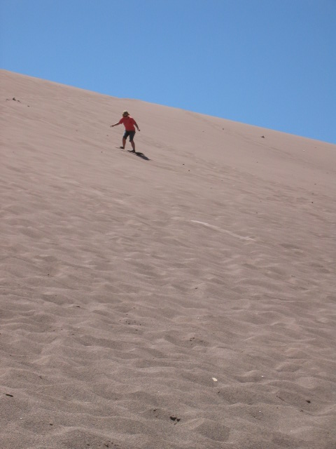
We set off in the bus, bikes mounted on top, for La Cumbre 4, 700 meters above sea level and at the foot of the Huayna Potosi mountain (6,088). There we were given our bikes and we adjusted them and circled around to get used to them. This was my first real mountain biking expereience, but not even rudimentary instructions were given to me on how to approach this!

The first 20 km was on paved road. This gave us time to adjust to riding the bikes and was thoroughly enjoyable- the bikes reach up to 80 km/hr. The temperature at the top of the mountain was very cold and it was a real struggle to be able to get our hands to function the brakes, but I guess our survival instinct kicked in.

1600 km down we reached the Unduavi drug paraphenalia checkpoint where we had to dismount and walk through. On the other side were several food stalls and many stray dogs. The Bolivians believe that the stray dogs are the returned souls of those who have died on the road and so are treated well. On the other side of the check point we had to commence a 5 km up hill. It was not very steep but at over 3000 m above sea level it was very hard work.

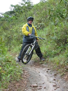
After the uphill we were given instructions on the off-road down hill and we set off. The first few hundred meters were very rough and I had serious doubts as to whether or not I was up to the task. The instructor told us that no one had died with their company- this was supposed to increase our confidence although the qualifier led us to deduce the obvious- that people had died with other companies. In fact, I later learnt that this was the case- several mountain bikers have died, many more injured and some saved only by hurling themselves off the bike before it went over the edge.

Little by little, however, my confidence increased and I let go of the breaks for longer periods of time. Hamish and the other guy in our group were fast. I, meanwhile, was comfortable bringing up the rear!


The path down is littered with reminders of the death toll- crosses, shrines and memorials decorate the edge of the road. On some of the most dangerous bends men and women stand in all conditions and signal to the oncoming traffic if it is safe to pass. We were told that the people all come from the same family- that of a man who lost his wife and children to the cliff and was determined to do something about it. They are paid only by the donations of passers by. Not all deaths on the road are, however, accidental. We were told the story of a Bolivian election where the opposition party became aware that they were not going to win the election. They took five of the most senior members of the government party and drove them to the La Paz- Coroico road and pushed them over the side.

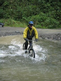
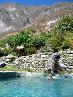
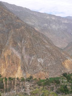
Further down the road widens and improves. By this time I was getting the hang of the bike and was able to let myself go to a far greater extent. It was amazing to feel the wind in my hair, the mud flying up to obscure my vision and all the while surrounded by the most incredibly beautiful countryside. It was brilliant to be able to ride under waterfalls goings over the road, and we managed to get a tad wet going through a few rivers the cross the road as well. The weather at La Cumbre had been perfect but most of the descent had been in the mist. I was not too unhappy not to be able to see the drop when we were high up but as we came closer to Coroico we were below the mist and could see all the way down the splendid valley.


We arrived at the small village at the bottom where we had a well deserved cold shower. It felt really great to be at the bottom- it was an incredible experience and the adrenalin was pumping so hard once we got down that we would happily have driven back up and done it all over again.
With a little more distance I am in two minds about the excursion. I read a few articles to get some facts to write this diary and read one article in particular written by a British guy who did the same trip but came across the cyclist who had fallen over the edge. He was with a friend who had trained in emergency medicine and another who had training in mountain rescue. They did their best to reach the woman and get her help- although the nearest hospital was well over two hours away. By the time they had managed to get her back up to the road she was already dead. He concluded that the road was too dangerous to be a tourist activity. He also thought that the trip was disrespectful to the locals who have no choice but to use this road and the tourists only make it more dangerous. It is hard to balance the truth of that argument against the income for the Bolivian economy that comes from this hugely popular (and quite pricey) tourist attraction. Still, it is a valid point and one that I had not considered before setting off on the trip.

Serious issues and dangers aside, having made it down the 72kms and 3600 metres in altitude in one piece I have to say that it was one of the most thrilling experiences of my life and I would still, despite everything, recommend the trip to others.

Monday, April 17, 2006

Potosi Silver Mines

Our next stop was Potosi, the highest city in the world, which sits at over 4000m and is home to the mountain Cerro Rico which over the last few hundred years has been pillaged for its silver and other precious metals and minerals. During the 1500s Potosi was probably the richest city in the world, but today it is run down and depressed.


A tour of the mines is one of the main attractions in Potosi so we got up early one morning to head up to Cerro Rico.

Our tour started with us getting kitted up in long pants, gumboots, jackets, helmet and headlamp and a battery belt (by this stage of our trip we were quite used to looking ridiculous) and heading to the street where the miners buy their provisions and I'm not talking about food...
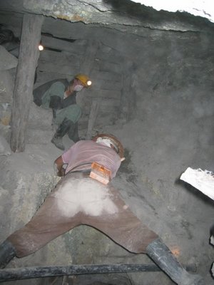
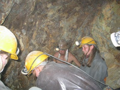
We bought dynamite (even kids can buy it in Potosi) a bottle of 96% alcohol (we all had to drink a mouthful before entering the mine) and bags of coca leaves (the miners´s staple diet). And yes, that is a stick of dynamite in my mouth!


Then we headed up the mountain, where we had a look around a silver processing plant

which was then followed up by our guides making up three dynamite bombs, lighting the short fuses in front of us and then allowing people to hold the dynamite and have their photos taken while the fuse quickly burnt down. OSH would not have had a bar of it!!

All of a sudden the time came for them to race 50 metres down the road and bury the dynamite in the ground. This was followed by them racing back along the road to where we were waiting with our cameras - they barely made it half the distance before the things exploded.

No harm done, except for rattling a few tourist's nerves and we headed into the mine. The mine was dark, dusty, hot and extremely claustrophobic as we moved between the different levels. I think it would have been 10 times worse if there had actually been men working down there but we were still glad to make our way out.

Sunday, April 16, 2006

Salar De Uyuni - The Salt Lakes

We set off at 8.00am for Bolivia. San Pedro is 2500 m above sea level. We arrived at the Bolivian border at 9.30 am and were already at 4500 m. We had spent the last five days traveling through the north of Chile and had seem many wonderful things, but the first morning in Bolivia surpassed them all.

The border crossing:


The first stop was the Largo Blanco- a large lake which was- yes you guessed it- white and rendered a perfect reflection of the surrounding mountains. Next onto the Largo Verde which by a huge stroke of coincidence was an emerald green lake. We stopped for lunch at a series of natural hot springs and bathed while our Bolivian guides prepared the food. The afternoon was no less sensational. We stopped at a geyser field- bubbling mud of all different colours, steam geysers and boiling water shooting from the ground. Next stop was a geyser that shot straight up into the air- this was at 4870 m.


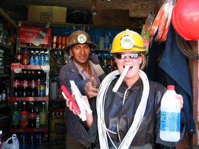
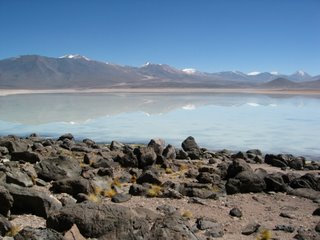
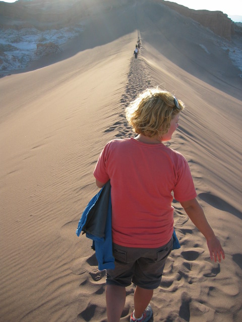
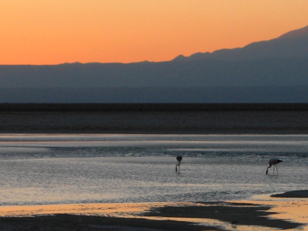
The next stop was the Largo Colorada- a red lake inhabited by thousands of Flamingos. It was very beautiful and we were told that we could walk around the lake and join the jeep at the other side. This gentle stroll around the lake was the last straw for our fragile bodies. I got back in the jeep and felt unwell, and Hamish froze the entire way around the lake. Fortunately, it was not far to the basic hostel which would be home for the night. It was only 4.00 pm or so but all of us in the jeep went straight to bed.


It is kind of hard to describe altitude sickness, but it is kind of like being drunk and hungover at the same time. I was having difficulty breathing and my heart was beating at twice the usual speed- even as I lay motionless in bed. Hamish could hardly move with the cold, and didn´t manage any dinner that night. The recommended speed of ascent is 300m per day above 3000 m with a rest day every 1000m. We had ascended more than 2500 m in two hours!

The second day of our journey was no less spectacular. We stopped to see strange rock formations in the desert.


The day was blighted by jeep problems. We had to change the tires three times, the third time having to borrow the spare from another vehicle. Towards the end of the day we were looking forward to getting to the salt hostel when the jeep got stuck in the mud. There ensued two hours of trying to get the jeep moving again. The combination of Bolivian jeep drivers and European passengers made for interesting viewing- 20 men and several different nationalities did not speed the process- too many cooks for sure.


I was about to give up hope when finally they were able to get the jeep going and we made it to the salt hostel. The hostel was surprisingly comfortable given the entire thing was constructed out of salt- walls, beds, tables.


Talk about saving the best to last! The third day was out-of-this-world breathtaking. We arrived before too long at the Salar d'Uyuni. This is the biggest salt flat in the world and is 12,000 square kms. It is the most reflective surface in the world and can be seen from the moon. We spent the entire day driving across the salt plain. We were very lucky with the timing. A few weeks before there had been too much water covering the plain to drive over it. We were told that in a couple more weeks there would be no water. As it was there was a few centimeters of water which the jeeps had no trouble driving through. The water meant that the surrounding mountains and clouds were reflected perfectly.


We stopped for lunch on the fish island- a small island in the middle of the salt plain made from coral and covered in huge cacti. The views out across the plain were spectacular.

Saturday, April 08, 2006

Adventures up the Chilean coast

Given that we only planned on spending one day in Chile, the 10 (reasonably expensive) days we ended up spending there were a pretty good bonus - 4 in Santiago and 6 making our way up the coast. Taking our time up Chile´s ridiculously long coast line turned out to be a great decision as we took in some gorgeous wild life, met some fantastic people and had time for plenty of activities on the way:

National reserve in Pinguino de Humbolt - colony of sea lions, sea otters, penguins, bottlenose dolphins and many bird species:

Our lunch spot at the reserve - Isla Damas:


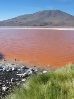
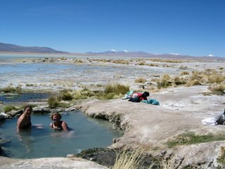
Bahia Inglesia - a great place to relax, have a game of international soccer, a bbq cooked by our guides and a couple of local vinos:
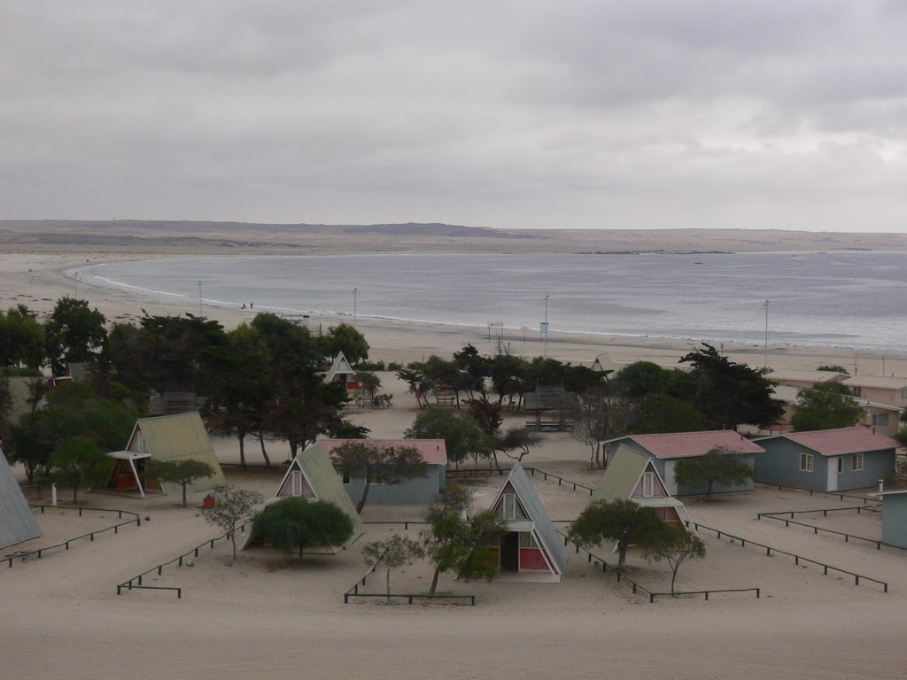

La Portada cliffs near Antofogasta - don´t be fooled - the town doesn´t live up to the same beauty as the coast:

Mano del Desierto (Hand of the desert). In the middle of the Atacama desert, where some meterological stations have not registered rain in over 50 years.

Oficiana Alamania - the desert used to be full of many nitrate mining operations - the main source of income during the 19th century - now kaput! This is a deserted cemetary where many graves have been robbed and open for viewing if you desire.

Valle de la luna (Moon Valley). Unfortunately Pink Floyd cancelled their concert here:


San Pedro de Atacama. Taking advantage of the lack of rain:


Salt lakes of Atacama on the tropic of Capricorn. Flamingos at sunset...


And Charlies Angels make a guest appearance: